Introduction
You’re checking your phone before heading out, and suddenly dark clouds appear from nowhere. Sound familiar? We’ve all been caught off guard by sudden weather changes. That’s exactly why the national weather service radar exists and why understanding it can literally save your life.
The National Weather Service operates one of the most sophisticated weather radar networks in the world. These powerful systems scan the skies 24/7, detecting everything from light rain to dangerous tornadoes. Whether you’re planning a weekend barbecue or need to know if that approaching storm is serious, the national weather service radar provides real-time data you can trust.
In this comprehensive guide, you’ll learn how these radar systems work, how to interpret what you’re seeing on those colorful weather maps, and why this technology matters for your daily safety. We’ll break down everything from basic radar reading to advanced features that meteorologists use. By the end, you’ll feel confident checking radar images and making informed decisions about weather-related plans.
Let’s dive into the fascinating world of weather radar technology.
Understanding National Weather Service Radar Basics
What Is Weather Radar?
Weather radar is essentially a sophisticated detection system that sends out radio waves and measures what bounces back. The National Weather Service uses a network called NEXRAD, which stands for Next Generation Radar. This system revolutionized weather forecasting when it was deployed in the 1990s.
The technology works by emitting pulses of electromagnetic energy into the atmosphere. When these pulses hit precipitation like rain, snow, or hail, they bounce back to the radar station. The system measures how long this takes and how strong the return signal is.
Think of it like shouting in a canyon and listening for the echo. The time it takes for the echo to return tells you how far away the canyon wall is. Weather radar does the same thing but with radio waves instead of sound.
The beauty of this system is its ability to detect not just precipitation but also its movement and intensity. This information gets processed into those familiar colorful maps you see on weather apps and websites.
The NEXRAD Network
The United States has 160 NEXRAD radar sites strategically positioned across the country. These sites provide overlapping coverage to ensure no gaps exist in weather monitoring. Alaska, Hawaii, Puerto Rico, and Guam also have their own radar installations.
Each radar site can scan up to 250 miles in all directions. The radar antenna spins in a complete circle, taking just a few minutes to complete one full rotation. It also tilts at different angles to build a three-dimensional picture of the atmosphere.
The network operates continuously, 365 days a year. Trained technicians maintain these systems to ensure they’re always ready when severe weather threatens. The reliability of the NEXRAD network has proven itself countless times during major weather events.
Data from all these radars feeds into the National Weather Service’s central systems. Meteorologists can view individual radar sites or composite images showing weather patterns across entire regions. This comprehensive view helps forecasters track storms as they develop and move.
How to Read National Weather Service Radar Images
Understanding the Color Scale
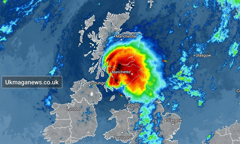
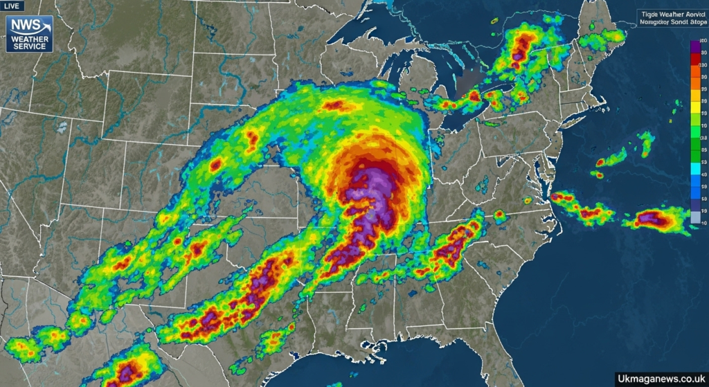
Those vibrant colors on radar images aren’t just for show. They represent different levels of precipitation intensity. The national weather service radar uses a standardized color scheme that most weather services follow.
Light blue and green indicate light to moderate rain. These colors mean you might need an umbrella but don’t signal dangerous conditions. Yellow and orange show heavier rainfall that could cause localized flooding or reduced visibility.
Red indicates very heavy precipitation. When you see red on the radar, expect intense rainfall, possibly mixed with hail. Purple and pink colors represent the most extreme precipitation, often associated with severe thunderstorms or very heavy snow.
The intensity scale measures reflectivity in units called dBZ (decibels of Z). Higher dBZ values mean stronger returns and typically heavier precipitation. Most radar displays include a legend showing exactly what each color represents.
Base Reflectivity vs. Composite Reflectivity
The national weather service radar offers several different viewing modes. Base reflectivity shows what the radar sees at a single elevation angle, usually the lowest one. This view gives you the most accurate picture of what’s happening at ground level.
Composite reflectivity combines data from all elevation angles into one image. This shows the strongest returns at any altitude, which helps identify severe weather features. Meteorologists often use this view to spot rotation in thunderstorms.
For everyday users, base reflectivity usually provides the most practical information. It shows what’s actually falling from the sky near your location. Composite views can sometimes show precipitation that’s occurring thousands of feet above ground and may never reach the surface.
Understanding which view you’re looking at helps prevent confusion. Some weather apps default to composite views, which might show precipitation that won’t affect you. Always check which radar mode your preferred weather source displays.
Velocity and Storm Relative Motion
Advanced radar products include velocity data that shows wind movement within storms. The national weather service radar can detect whether precipitation is moving toward or away from the radar site. This capability is crucial for tornado detection.
Red colors on velocity displays indicate movement away from the radar. Green colors show movement toward the radar. When you see red and green areas very close together, that suggests rotation. Strong rotation often precedes tornado formation.
Storm relative motion removes the overall storm movement to highlight internal circulation. This helps meteorologists spot mesocyclones, which are rotating updrafts that can spawn tornadoes. These advanced features explain why tornado warnings have become more accurate over the years.
Most casual users won’t need to interpret velocity data regularly. However, understanding that these capabilities exist helps you appreciate why National Weather Service warnings are so reliable. The technology sees things human eyes cannot.
Key Features of National Weather Service Radar
Real-Time Updates
One of the biggest advantages of the national weather service radar is its refresh rate. Data updates every few minutes, providing near real-time information about changing conditions. This frequency matters enormously when severe weather develops rapidly.
Commercial weather services often delay radar data by several minutes due to processing and distribution. The National Weather Service provides the most current data available. During rapidly evolving situations, those extra minutes can make a critical difference.
You can access this data directly through the National Weather Service website. Their radar viewer might not look as polished as commercial weather apps, but it provides unfiltered, up-to-the-minute information. I often use it when storms are nearby because I want the freshest data possible.
The real-time nature of the system also helps meteorologists issue timely warnings. When a tornado signature appears on radar, forecasters can get warnings out within minutes. This quick response time has saved countless lives over the years.
Storm Tracking Capabilities
The national weather service radar doesn’t just show where precipitation is now. It also tracks storm movement and predicts where systems are heading. Storm tracking algorithms analyze multiple radar scans to determine speed and direction.
Most radar displays include storm tracks showing projected paths. These appear as lines or arrows extending from current storm locations. While storms can change direction, these tracks provide valuable guidance for planning.
The system can also identify storm cells and assign them unique identifiers. This helps meteorologists and emergency managers communicate about specific threats. You might hear forecasters reference “the storm cell approaching downtown” based on radar tracking.
Automated algorithms continuously scan for severe weather signatures. When detected, these systems alert forecasters who then investigate further. This combination of artificial intelligence and human expertise creates a robust warning system.
Warning Integration
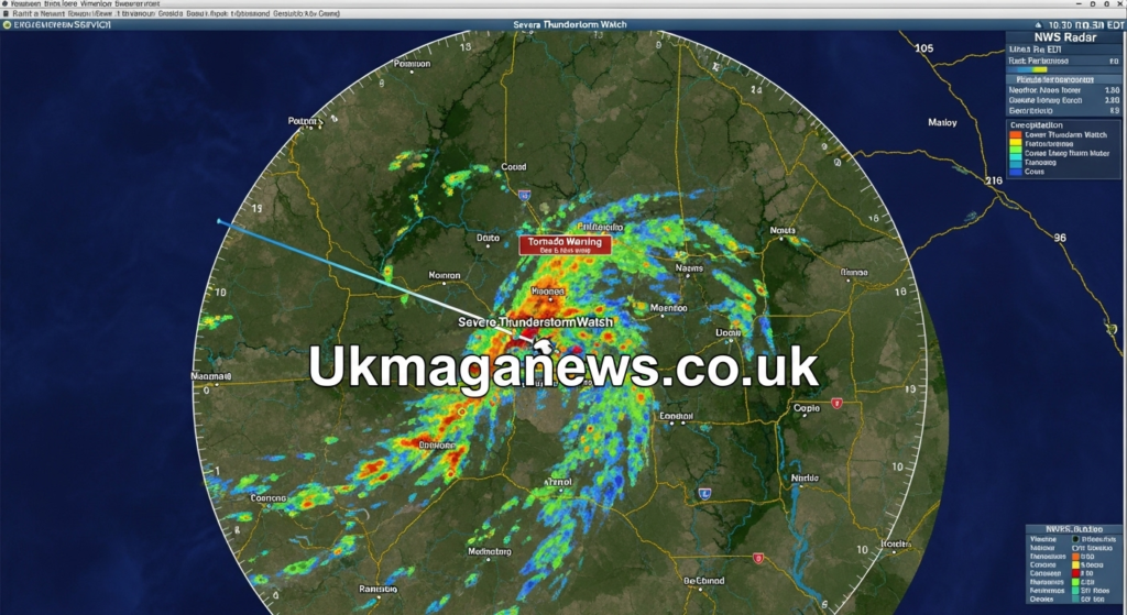
The National Weather Service issues watches and warnings based heavily on radar data. When you see a tornado warning polygon overlaid on a radar map, that’s direct integration between detection and public alert systems. The national weather service radar provides the evidence supporting these critical warnings.
Warnings get issued for specific areas, not entire counties. This precision comes from radar’s ability to pinpoint exactly where dangerous weather is occurring. You might be under a warning while someone ten miles away is not.
Different warning types correspond to different radar signatures. Tornado warnings require rotation signatures. Severe thunderstorm warnings need evidence of large hail or damaging winds. Flash flood warnings come from rainfall estimates exceeding certain thresholds.
Understanding this connection between radar and warnings helps you trust the system. These aren’t wild guesses but data-driven decisions based on sophisticated technology. When a warning is issued for your area, take it seriously.
Practical Applications of Weather Radar
Daily Weather Planning
You don’t need severe weather to benefit from the national weather service radar. Checking radar before leaving for work or planning outdoor activities has become routine for millions of people. The technology helps you make informed decisions about daily life.
Rain timing is one of the most common uses. Radar shows not just that it’s raining somewhere but where and when it might reach you. You can often see gaps between rain bands where you might squeeze in outdoor activities.
I personally check radar most mornings during my coffee. It takes 30 seconds and frequently influences my commute timing or whether I’ll bike or drive. This simple habit has kept me dry countless times.
Travel planning also benefits from radar monitoring. Long drives become safer when you can see what weather lies ahead. If heavy storms sit along your route, you might delay departure or choose an alternate path.
Severe Weather Safety
During severe weather outbreaks, the national weather service radar becomes a critical safety tool. Knowing exactly where dangerous storms are and where they’re heading can help you take appropriate shelter. This information literally saves lives every year.
If you’re in a tornado watch area, monitoring radar helps you stay aware of developing threats. You’ll see when storms intensify or when rotation develops. This awareness gives you precious extra minutes to reach shelter if warnings are issued.
For areas prone to flash flooding, radar-based rainfall estimates show where dangerous amounts of rain are falling. You can see if your location is getting saturated or if the heaviest rain is passing by. This information helps you avoid flooded roads.
Lightning safety also connects to radar monitoring. If you see precipitation approaching on radar, lightning is likely nearby even if you haven’t seen it yet. The saying “when thunder roars, go indoors” applies when rain appears on your local radar.
Agriculture and Outdoor Industries
Farmers rely heavily on the national weather service radar for operational decisions. Timing field work around rain, monitoring potential hail threats to crops, and planning irrigation all involve radar data. Agriculture is a billion-dollar industry where weather information drives critical choices.
Construction companies use radar to plan daily activities. Concrete pours require dry conditions for hours after completion. Roofing work can’t happen in rain. Checking radar helps contractors schedule efficiently and avoid costly weather delays.
Outdoor event planners constantly monitor radar during setups and activities. Concerts, festivals, sporting events, and weddings all depend on weather cooperation. Real-time radar helps organizers make tough calls about delays or cancellations.
Aviation relies on weather radar for safe operations. Pilots check radar before and during flights to avoid hazardous weather. Air traffic controllers use radar information to route planes around dangerous storms. This coordination keeps millions of passengers safe annually.
Advanced Radar Products and Features
Dual Polarization Technology
Modern NEXRAD radars use dual polarization technology, a major upgrade implemented in recent years. Traditional radar sent out pulses in one orientation. Dual pol radar sends both horizontal and vertical pulses. This provides far more detailed information about what the radar is detecting.
The technology can distinguish between rain, hail, snow, and even non-weather objects. This helps reduce false alarms and improves precipitation estimates. Meteorologists can now identify giant hail more reliably, leading to better warnings.
Dual pol radar can also detect debris lofted by tornadoes. This “debris ball” signature provides confirmation that a tornado is on the ground and causing damage. Before this technology, confirmation often relied on storm spotters or damage reports.
For users, dual pol improvements mean more accurate forecasts and warnings. The national weather service radar sees more detail than ever before. This translates to better information for you when you need it most.
Rainfall Estimation
The national weather service radar produces rainfall estimates by measuring reflectivity and applying mathematical algorithms. These estimates help forecasters predict flooding and allow emergency managers to prepare responses. The technology has become increasingly accurate over the years.
Rainfall rates show how much rain is falling per hour in different areas. This information appears on specialized radar products designed for flooding analysis. When rates exceed several inches per hour, flash flooding becomes likely.
Storm total rainfall shows accumulated precipitation since a storm began. This helps identify areas at greatest flood risk. You might see six inches have fallen in one location while nearby areas received only one inch.
During major rain events, I check these rainfall products to understand my local situation. General radar shows precipitation, but rainfall estimates quantify exactly how much has fallen. This distinction matters when flooding threatens.
Hail Detection
Specialized algorithms analyze radar data to detect and estimate hail size. The national weather service radar can identify hail cores within thunderstorms where large hail is likely. These products help meteorologists issue severe thunderstorm warnings with specific hail size estimates.
The system distinguishes between small hail, which might damage plants, and large hail, which can destroy cars and roofs. Golf ball size hail receives particular attention as it poses significant danger to people and property.
Hail detection has improved dramatically with dual polarization technology. The radar can now identify the irregular shapes of hailstones compared to the more uniform shapes of raindrops. This leads to more confident hail warnings.
If you hear a severe thunderstorm warning mentioning baseball size hail, that information came from radar analysis. The specificity of modern warnings helps you understand exactly what threat you face.
Accessing National Weather Service Radar
Official NWS Resources
The National Weather Service website offers free access to all radar data. Their radar viewer at weather.gov provides unfiltered, real-time information directly from NEXRAD sites. The interface might seem basic compared to slick commercial apps, but the data is authoritative.
You can select individual radar sites or view regional composites. The site offers all radar products including base reflectivity, velocity, and precipitation estimates. This comprehensive access costs nothing and requires no registration.
The NWS mobile website works on smartphones, though dedicated apps often provide better mobile experiences. Still, knowing how to access the official source ensures you always have a backup option. Bookmark the radar page for quick access during emergencies.
Local National Weather Service offices also maintain websites with regional information. These often include radar loops, current warnings, and local forecaster analysis. Building familiarity with your local office’s resources improves your weather awareness.
Third-Party Weather Apps
Countless weather apps incorporate national weather service radar data. Popular options include Weather Underground, RadarScope, MyRadar, and many others. These apps add features like smoother animation, location-based alerts, and more intuitive interfaces.
RadarScope is particularly popular among weather enthusiasts and professionals. It provides professional-grade radar displays with all the advanced products available. The app costs money but offers unmatched detail and customization.
Free apps like MyRadar or Weather Channel provide good radar displays for casual users. They overlay warnings and watches, making it easy to see if alerts affect your location. Most people find these apps perfectly adequate for daily weather monitoring.
Remember that third-party apps get their data from the National Weather Service. They add presentation and features but don’t generate original radar data. When you see radar on any app, you’re viewing national weather service radar information.
Understanding Limitations
Weather radar has limitations you should understand. The curvature of the Earth means radar beams rise with distance. Far from a radar site, the beam passes over low-level features. This creates coverage gaps, especially in mountainous terrain.
Radar also can’t detect everything. Very light precipitation might not produce enough return signal to appear on displays. The system sees precipitation, not clouds, so cloudy skies don’t necessarily show up.
Beam blockage from mountains or tall buildings creates shadow zones where radar coverage is poor. The National Weather Service knows where these gaps exist and positions radars to minimize them. Still, some areas have inherently limited coverage.
Ground clutter from buildings, trees, and terrain can sometimes appear on radar as false precipitation. Sophisticated filtering removes most of this, but you might occasionally see artifacts on radar displays. Experience helps you recognize these anomalies.
The Future of Weather Radar Technology
Upcoming Improvements
The National Weather Service continuously works to improve radar capabilities. Current research focuses on faster scanning, better resolution, and improved automated detection algorithms. The next generation of upgrades will make the national weather service radar even more powerful.
Phased array radar technology represents a potential future advancement. These systems could scan the entire atmosphere in seconds rather than minutes. This speed would dramatically improve tornado warning lead times and track rapidly evolving storms.
Artificial intelligence and machine learning are being applied to radar interpretation. Computers can now identify patterns that might escape human notice. These technologies assist forecasters in making faster, more accurate decisions.
Enhanced collaboration with other observing systems is also improving. Combining radar with satellite data, surface observations, and computer models creates a comprehensive picture of the atmosphere. Integration of multiple data sources represents the future of weather forecasting.
Climate and Weather Pattern Changes
As climate patterns shift, the national weather service radar network becomes even more critical. More intense rainfall events are occurring in many regions. Better rainfall estimation from radar helps communities prepare for and respond to flooding.
Severe weather patterns are evolving, with some areas experiencing increased tornado activity. Enhanced radar capabilities help detect these threats wherever they occur. The technology adapts to changing weather patterns better than older systems could.
Researchers use decades of archived radar data to study how weather patterns have changed. This historical record provides insights into trends and helps improve long-range predictions. The value of the radar network extends beyond day-to-day forecasting.
Future climate conditions will likely bring weather challenges we haven’t fully anticipated. Having robust radar systems in place helps ensure we can detect and respond to whatever develops. Investment in weather infrastructure pays dividends for public safety.
Why the National Weather Service Radar Matters
The national weather service radar network represents one of the most successful public infrastructure investments ever made. The system has prevented countless deaths through improved warnings and forecasts. Economic benefits from better weather information run into the billions of dollars annually.
Unlike many government services, weather radar provides something tangible you can access directly. You’re not relying on intermediaries or paying subscription fees. The data is free, authoritative, and continuously updated.
This technology connects all of us regardless of where we live. The farmer in Iowa, the commuter in Seattle, and the beach-goer in Florida all benefit from the same sophisticated system. This democratic access to critical information exemplifies good governance.
As extreme weather becomes more common and impactful, tools like radar become increasingly essential. Understanding how to use these resources empowers you to protect yourself and your family. The few minutes spent learning radar basics could prove invaluable during a future emergency.
Conclusion
The national weather service radar has transformed how we interact with weather. What once required expertise to interpret now sits in your pocket, accessible with a few taps. This democratization of weather information represents genuine progress in public safety.
You now understand how the technology works, what those colorful displays mean, and how to apply radar information to daily decisions. Whether checking if you need an umbrella or monitoring a severe storm, you have the knowledge to use this powerful tool effectively.
The sophistication of the national weather service radar continues growing through technological advances and improved understanding. As users, we benefit from decades of research and billions in infrastructure investment. This resource belongs to all of us and works for us every single day.
Next time you check weather radar before heading out, take a moment to appreciate the remarkable technology making it possible. Then use that information to make smart decisions that keep you safe and dry. The radar is there for you, so make it work to your advantage.
Have you checked your local radar today? What weather conditions are you tracking right now?
Frequently Asked Questions
How accurate is the national weather service radar?
The national weather service radar is highly accurate for detecting and measuring precipitation within its coverage area. Accuracy exceeds 90% for precipitation detection and location. Intensity estimates have improved significantly with dual polarization technology. However, very light precipitation or areas far from radar sites may have reduced accuracy.
Can weather radar detect tornadoes directly?
Weather radar cannot see tornadoes themselves but detects rotation patterns and debris associated with them. Velocity products show spinning motions within storms that indicate tornado potential. Dual polarization radar can detect debris lofted by tornadoes, confirming they are on the ground. This technology has dramatically improved tornado warning accuracy and lead times.
Why does radar show rain that never reaches the ground?
Radar detects precipitation at various altitudes, including rain that evaporates before reaching the surface. This phenomenon, called virga, is common in dry climates. Composite radar views are more likely to show this than base reflectivity. Checking surface observations alongside radar helps determine if precipitation is actually reaching the ground.
How often does the national weather service radar update?
NEXRAD radars complete a full volume scan every four to six minutes under normal conditions. During severe weather, forecasters can switch to faster scanning modes that update every couple of minutes. This near real-time information allows for rapid warning issuance when dangerous weather develops. Commercial weather services may introduce additional delays in their displays.
What do the different radar colors mean?
Radar colors represent precipitation intensity. Blue and green indicate light to moderate precipitation. Yellow and orange show heavier precipitation. Red indicates very heavy rain or hail. Purple and pink represent extreme precipitation intensity. The color scale measures radar reflectivity, with higher values indicating stronger returns from precipitation.
Can I access weather radar for free?
Yes, the National Weather Service provides free access to all radar data through weather.gov. This official source offers real-time, unfiltered information from all NEXRAD radar sites. Many weather apps also display this same data with enhanced features and interfaces. The core radar information is a public resource available to everyone.
Why are there gaps in radar coverage?
Gaps occur primarily due to Earth’s curvature causing radar beams to overshoot low-level features at distance. Mountains and terrain can also block radar beams, creating shadow zones. The 160-radar network is positioned to minimize coverage gaps, but some limitations remain. Most populated areas have excellent coverage from multiple overlapping radar sites.
What is the range of weather radar?
NEXRAD radars can detect precipitation up to 250 miles away. However, effectiveness decreases with distance as the beam rises higher above ground. The most accurate and useful coverage typically extends about 100 to 150 miles from each radar site. Severe weather features can sometimes be detected beyond 200 miles under ideal conditions.
How does radar detect hail?
Radar identifies hail through extremely strong reflectivity returns and specific patterns in dual polarization data. Large hailstones produce different radar signatures than raindrops due to their size and irregular shape. Algorithms analyze these characteristics to estimate hail size. Dual polarization technology has dramatically improved hail detection accuracy compared to older radar systems.
Can weather radar see through clouds?
Yes, radar beams pass through clouds easily. The system detects precipitation particles, not cloud droplets which are too small. This allows radar to see precipitation occurring within clouds and provide information about storm structure. Clouds without precipitation generally do not appear on radar displays, which is why cloudy skies don’t always show up.
Also Read Ukmaganews.co.uk